
Congratulations! Your promo code PROMOCODE will be automatically applied when you check out – enjoy.


If you need any help or advice at all on this drone, or its real world application, please give our experts a call on 0330 041 2733
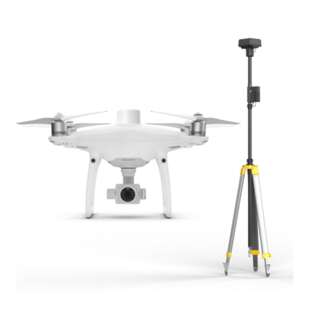
Phantom 4 RTK + D-RTK 2 Mobile Station Combo
Visionary Intelligence. Elevated Accuracy.
Upgrade your next mapping mission with the Phantom 4 RTK – the most compact and accurate low altitude mapping solution.
Next Generation Mapping
DJI has rethought its drone technology from the ground-up, revolutionizing its systems to achieve a new standard for drone accuracy – offering Phantom 4 RTK customers centimeter - accurate data while requiring fewer ground control points.
Centimeter level positioning system
A new RTK module is integrated directly into the Phantom 4 RTK, providing real-time, centimeter-level positioning data for improved absolute accuracy on image metadata. Sitting just beneath the RTK receiver is a redundant GNSS module, installed to maintain flight stability in signal-poor regions such as dense cities. Combining both modules, the Phantom 4 RTK is able to optimize flight safety while ensuring the most precise data is captured for complex surveying, mapping and inspection workflows.
Fit the Phantom 4 RTK to any workflow, with the ability to connect this positioning system to the D-RTK 2 Mobile Station, NTRIP (Network Transport of RTCM via Internet Protocol) using a 4G dongle or WiFi hotspot, or store the satellite observation data to be used for Post Processed Kinematics (PPK).
Gather Accurate Data with TimeSync
To take full advantage of the Phantom 4 RTK's positioning modules, the new TimeSync system was created to continually align the flight controller, camera and RTK module. Additionally, TimeSync ensures each photo uses the most accurate metadata and fixes the positioning data to the center of the CMOS – optimizing the results from photogrammetric methods and letting the image achieve centimeter-level positioning data.
Precise Imaging System
Capture the best image data with a 1-inch, 20 megapixel CMOS sensor. Mechanical shutter makes mapping missions or regular data capture seamless as the Phantom 4 RTK can move while taking pictures without the risk of rolling shutter blur. Due to the high resolution, the Phantom 4 RTK can achieve a Ground Sample Distance (GSD) of 2.74 cm at 100 meters flight altitude.
To ensure each Phantom 4 RTK offers unparalleled accuracy, every single camera lens goes through a rigorous calibration process where radial and tangential lens distortions are measured. The distortion parameters gathered are saved into each image's metadata, letting post-processing software adjust uniquely for every user.
Purpose-Built Flight Planning Application
A new GS RTK app allows pilots to intelligently control their Phantom 4 RTK, with two planning modes – Photogrammetry and Waypoint Flight – alongside a more traditional flight mode. The planning modes let pilots select the drone's flight path while adjusting overlap rate, altitude, speed, camera parameters and more, offering an automated mapping or inspection workflow.
The GS RTK app has been built with its users in mind and therefore has a range of features built for specific mapping or inspection workflows. The app has implemented direct loading of KML/KMZ files for in-office flight planning, a new shutter priority mode to keep exposure consistent across all photos and a strong wind alarm to warn pilots of adverse conditions.
Mobile SDK Supported
The Phantom 4 RTK is compatible with the DJI Mobile SDK, opening up its functions to automation and customization through a mobile device.
OcuSync Transmission System
Enjoy stable and reliable HD image and video transmission at distances of up to 7 km, great for mapping larger sites.
*Unobstructed, free of interference, when FCC compliant. Maximum flight range specification is a proxy for radio link strength and resilience. Always fly your drone within visual line of sight unless otherwise permitted.
Seamless Compatibility with D-RTK 2 Mobile Station
Support your Phantom 4 RTK missions with the D-RTK 2 Mobile Station – providing real-time differential data to the drone and forming an accurate surveying solution. The Mobile Station's rugged design and OcuSync transmission system ensures you can gain centimeter- level accurate data with your Phantom 4 RTK in any condition.
Start Mapping Today
With a built-in flight planning app (GS RTK) and an easy method to collect RTK data (RTK Network or D-RTK 2 Mobile Station), pilots have a full solution for any surveying, mapping or inspection workflow – right out of the box.
Construction
- Keep track of your sitesand conduct accurate measurements with a regular, accurate map of your site.
Agriculture
- Collect detailed analyses of your crops to measure expected yield, identify rising concerns and more.
Energy
- Conduct detailed inspections of assets with a substantially decreased risk of loss of
D-RTK 2 High Precision GNSS Mobile Station
Optimized Accuracy. Ultimate Reliability.
D-RTK 2 High Precision GNSS Mobile Station (D-RTK 2 Mobile Station) is DJI's upgraded high-precision GNSS receiver that supports all major global satellite navigation systems, providing real-time differential corrections that generate centimeter-level positioning data for improved relative accuracy.
Centimeter-Level Positioning
D-RTK 2 Mobile Station fully supports GPS, GLONASS, Beidou, and GALILEO signals. Easy and quick to set up, the D-RTK 2 Mobile Station provides real-time differential data for drones to achieve centimeter-level positioning accuracy. The built-in high-gain antenna guarantee better signal reception from more satellites even when obstructions are present.
Stay Connected for Any Mission
D-RTK 2 Mobile Station supports communication via 4G, OcuSync, WiFi, and LAN, ensuring uninterrupted, stable data transmission under any application scenario. Up to 5 remote controllers* can be connected to D-RTK 2 Mobile Station simultaneously. This makes coordinated operations involving multiple drones a possibility, significantly improving efficiency. * MG-1P and Phantom 4 RTK standard remote controllers.
Durability You Can Trust
Featuring IP67 level ingress protection and a lightweight carbon fiber body, the D-RTK 2 Mobile Station is ultra-portable and up for any task, no matter how tough. The built-in IMUs monitor movements and calibrate the tilt sensors to alert the operator of any abnormalities during the mission, minimizing risks.
A Comprehensive Solution
D-RTK 2 Mobile Station is compatible with Phantom 4 RTK and MG-1P RTK. It can be used as a Continuously Operating Reference Station (CORS), which provides high precision positioning data within the cover range of the base station, making it the ideal tool for surveying, aerial inspections, agriculture, and other industrial applications.
What's in the box?
- 1 x P4 RTK Drone
- 1 x Remote Controller (With Screen)
- 1 x D-RTK2 Mobile Station
- 1 x D-RTK2 Tripod
- 4 x Propeller Pairs
- 2 x Intelligent Flight Batteries
- 1 x AC Power Cable
- 1 x WB37 Battery
- 1 x AC Power Adapter
- 1 x WB37 Charging Hub
- 1 x P4 Battery Charging Hub
- 1 x Micro-USB Cable
- 1 x USB-C OTG Cable
- 1 x USB-C Cable
- 1 x Dongle
- 1 x Gimbal Clamp
- 1 x 16GB microSD Card
- 1 x Carrying Case
